20 November 2013

The Monsters of Olaus Magnus’ 1539 Map

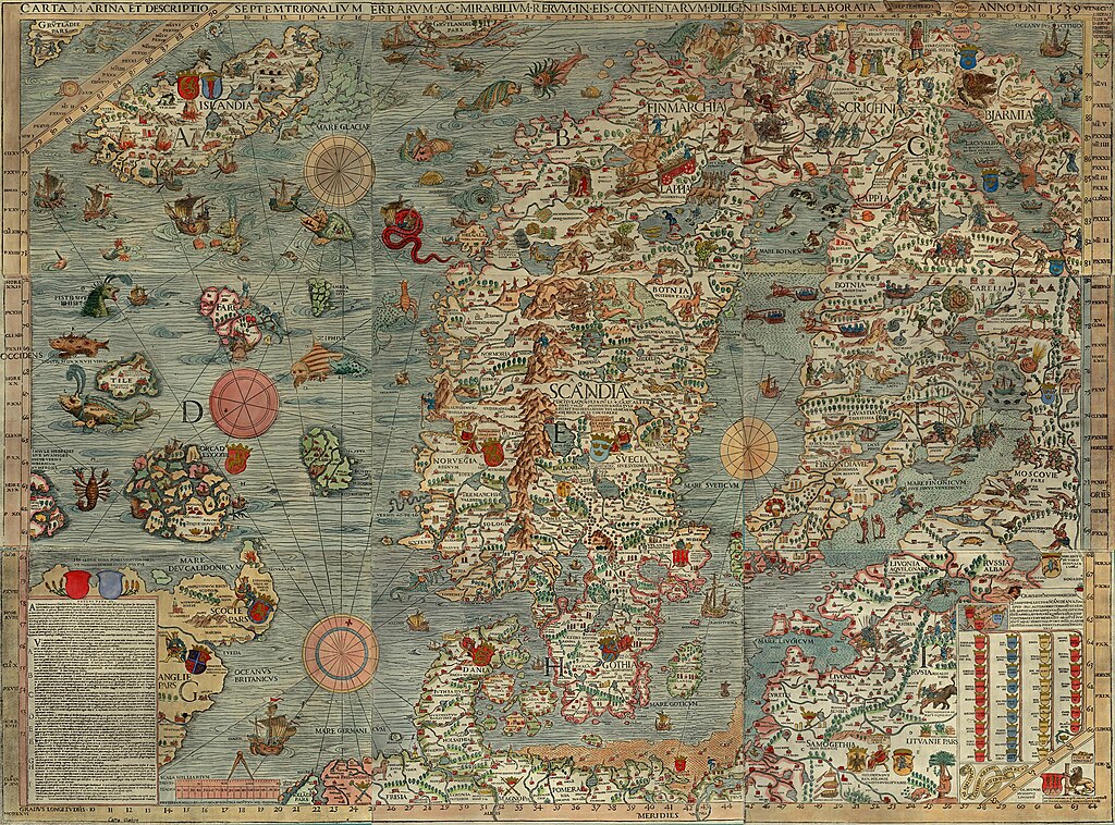
Monsters and maps.  (Click here for an interactive version.)
Olaus Magnus, Carta Marina..., 1539.
In 1538, after twelve years of work, Swedish Catholic priest Olaus Magnus (1490–1557) had his large map of the Nordic northland published in Venice.  The numerous sea monsters, land creatures, and vignettes immediately capture a viewer's attention.  The Carta Marina, as it was called, is made up of nine large woodblock-printed sheets, measuring about 5.5 feet wide and 4 feet high (1.70 m by 1.25 m).  The editions that have come down to the present, housed in Munich and Uppsala, are delightfully covered.

The full name of the map is: Carta marina et Descriptio septemtrionalium terrarum ac mirabilium rerum in eis contentarum, diligentissime elaborata Anno Domini 1539 Veneciis liberalitate Reverendissimi Domini Ieronimi Quirini ("A Marine map and Description of the Northern Lands and of their Marvels, most carefully drawn up at Venice in the year 1539 through the generous assistance of the Most Honourable Lord and Patriarch Hieronymo Quirino").  It was the first map printed in the south of Europe to show extensive and accurate detail as well as place-names.  Olaus Magnus also penned a book titled Historia de Gentibus Septentrionalibus ("A Description of the Northern Peoples"), which was printed in 1555.

Scholar Joseph Nigg has just released a book about the Carta Marina with the University of Chicago Press called Sea Monsters: A Voyage Around the World’s Most Beguiling Map.  The online newsmagazine Slate has posted a short introduction to the map, complete with a fully zoomable and clickable depiction of some of its monstrous creatures.

Chet Van Duzer, a scholar at the Library of Congress, has also recently published a book about sea monsters on maps titled, Sea Monsters on Medieval and Renaissance Maps.  As Van Duzer notes: "The creatures look purely fantastic. They all look like they were just made up.  But, in fact, a lot of them come from what were considered, at the time, scientific sources."

10 November 2013

The Influence of Greco-Roman Mapping on the First European Age of Exploration

Ptolemy's world map, reconstituted from Ptolemy's Geographia in the 15th century
The Institute for the Study of the Ancient World at New York University is hosting an exhibit on the legacy of Greco-Roman mapmaking, and, since many of our surviving examples of such maps are recreations from the Renaissance, how the cartography of Greece and Rome was rediscovered and utilized in a whole new era.

The exhibit, titled "Measuring and Mapping Space: Geographic Knowledge in Greco-Roman Antiquity" is located in Manhattan and runs through January 5, 2014, but has a very strong web presence.  Included online are copies of the printed material, online resources, a YouTube video, and an extensive checklist of objects on display.

Roger S. Bagnall, a director at the institute, noted that "Our exhibitions and digital teams present a 21st-century approach to the ancient mentality concerning geographic space and how it is represented."  Scholars should, when possible, try to see the world in the eyes of the historical subjects they are researching.  One of the exhibit's guest curators said that "Geography is not just maps.  There is also the cognitive side underlying mapping."

As John Wilford Noble notes in a New York Times piece on the exhibit, the worldview and conceptions of the classical thinkers deeply influenced the explorers of the first European Age of Exploration.  Wilford notes: "Even Ptolemy’s errors were influential. Instead of sticking to Eratosthenes’ more accurate estimate of Earth’s size, Ptolemy handed down a serious underestimate that later apparently emboldened Columbus to think he could sail west to reach China or Japan."


30 October 2013

Penn Museum's Great Voyages: Travels, Triumphs, and Tragedies Lecture Series

Gilgamesh, the first explorer?
(Source: The Chaldean Account of Genesis, 1876)
The University of Pennsylvania Museum of Archaeology and Anthropology, commonly called Penn Museum, is hosting a monthly lecture series through June 2014 titled Great Voyages: Travels, Triumphs, and Tragedies.  The series will feature a range of topics by experts in several fields.  The upcoming lectures are:

November 6
Ignacio Gallup-Diaz, Associate Professor, History, Bryn Mawr College
Ferdinand Magellan and the First Circumnavigation of the Globe, 1519–1522

December 4
Paul Cobb, Professor, Islamic History, University of Pennsylvania
Traveler's Tips from the 14th Century: The Detours of Ibn Battuta

January 8
Steve Tinney, Associate Curator-in-Charge, Penn Museum Babylonian Section
Gilgamesh: Journeys to the End of the World

February 5
Robert Ballard, Director of the Center for Ocean Exploration at the Graduate school of Oceanography at URI, and President of Ocean Exploration Trust
Lost History Beneath the Sea from Titanic to the Iron Age

March 5
Clark Erickson, Curator-in-Charge, Penn Museum American Section
Thor Heyerdahl and Kon Tiki: A Grand Experiment in Archaeology

April 2
Peter Struck, Associate Professor, Classical Studies, University of Pennsylvania
The Odyssey, Nostalgia, and the Lost Home

May 7
Brian Rose, Curator-in-Charge, Penn Museum Mediterranean Section
Searching for the Golden Fleece with Jason and the Argonauts

June 4
Michael Weisberg, Associate Professor, Philosophy, University of Pennsylvania
Darwin's Beagle Voyage

Check out Penn Museum's website for further details.


14 October 2013

Osher Map Library Presents "To the Ends of the Earth and Back"

Mercator's view of the North Pole.
Gerardus Mercator, Septentrionalium Terrarum descriptio, 1623.
The Osher Map Library at the University of Southern Maine in Portland, Maine, is now hosting an exhibit titled: "To the Ends of the Earth... and Back: Selections from the Jay I. Kislak Polar Collection," highlighting the centuries old quest to understand, map, and explore the Earth's polar regions.

"To the Ends of the Earth" showcases more than eighty maps, charts, photographs, and other artifacts, from the Jay I. Kislak Polar Collection.  The exhibit is on view through February 27, 1:00 to 4:00 p.m., Tuesdays to Thursdays (with tours available by appointment).


29 September 2013

Atlas of True Names

Atlas of True Names: World Map (2008) from Kalimedia
(click to enlarge)
Explorers and cartographers, and those who study them, like members of the Society for the History of Discoveries, are often awash in place-names.  Toponyms tell us about the history of a place, who named it, why they named it, etc.  Explorers, like Columbus or La Salle or Cook gave names, recorded indigenous names, and mapmakers adopted and/or altered the geographical information they received.

But what do the names mean?  Stephan Hormes and Silke Puest at Kalimedia have created a wonderful series of maps they call an "Atlas of True Names."  They've replaced place-names like Reykjavik and and Washington with their true meanings, "Smoky Place" and "Marshton."  The Atlantic Ocean becomes "World Stream by the Mountain of Mountains."  Portugal is "Warm Port."

Check out their world map of True Names
And visit their website for more examples from their Atlas of True Names

05 September 2013

Society for the History of Encounters?

"Islands and ice, mostly," says Bill Rankin of his map Actual European Discoveries.
(Click the link below for a larger version to see detail.)
In the past few decades, there has been a discussion amongst historians, geographers, anthropologists and the like about just what to call what was going on in the “Age of Discovery.”  Was it “discovery”? “exploration”? “encounter”? “invasion”? “reconnaissance”?

The term for the longest time has been discovery.  Older histories (and the general public still) used “Columbus’s discoveries” or “Columbus discovered America” and the like.  But this has been pointed out to be Eurocentric.  Columbus ran across places that other people had already discovered!  They were discovered by the indigenes who lived there!  So scholars, like Brian Harley, used terms such as the “Columbian encounter.”  The word encounter, indeed, has become the popular term used in academe these days, though it has its detractors.  “Encounter” is here to stay alongside “discovery.”  As Marvin Lunenfeld writes in the introduction to 1492—Discovery, Invasion, Encounter: “The neutral word encounter has recently come into general scholarly use.  Encounter seems friendly enough, evoking the idea of social gatherings….  If all that happened in 1492 was that Columbus ‘encountered’ the Amerindians, the historian would successfully escape the ethnocentric connotations of a discovery and the violent implications of an invasion.”

Dr. Bill Rankin, Assistant Professor of History of Science at Yale University, has constructed a map titled Actual European Discoveries for his website Radical Cartography that shows just what little Europeans actually discovered in the sense of no other humans were there to greet them.  As Rankin notes (a tad sarcastically, he admits): “Every Columbus Day, were reminded of the difference between discovery and discovery—and rightly so.  But let's not sell Europe short; after all, European explorers found plenty of diminutive islands that no human had ever seen before, along with extravagant amounts of ice and snow.”

If the Society for the History of Discoveries was holding its fourth annual meeting this year instead of its fifty-fourth, would it be named the “Society for the History of Encounters”?


26 August 2013

Speakers at the Fifty-fourth Annual Meeting of the Society for the History of Discoveries

A depiction of what might be Florida from the 1502 Cantino map.
The following is a list if speakers for the Fifty-fourth Annual Meeting of the Society for the History of Discoveries (SHD), which will be held this year in Tampa, Florida, at the Tampa Bay History Center (TBHC) from October 31–November 3, 2013.

Speakers

ALTIC, Mirela (Croatia): "Missionary Cartography of the Amazon after the Treaty of Madrid (1750): A Jesuit's Contribution to the Demarcation of Imperial Frontiers"

BECK, Lauren: "A Moroccan Ambassador’s Travelogue in Spain (1690-91) and Its Legacy"

BLICK, Jeffrey: "The Case for San Salvador as the Site of the 1492 Columbus Landfall: Principles of Historical Archaeology Applied to Current Evidence"

COWDREY, Peter: "Mapping La Florida"

DELIZ, Michael: "The Digital Reconstruction of El Mapa Militar de Puerto Rico: An Analysis of the Spanish Military Topographic Project in Puerto Rico, 1872-1897"

EDNEY, Matthew: "The Transatlantic Circulation of Geographical Maps before 1763"

GASPAR, Joaquim (Portugal): "The representation of the Western Indies in the early Iberian cartography: a cartometric approach"

MATTHEWS, Jim: "Love Letters and Lesser Beings: Travel Accounts of French and Moroccan Diplomats during the Ancien Régime"

McGUIRK, Don: "Is North America REALLY pictured on the Waldseemüller World Map of 1507?"

MILANICH, Gerald T. (Florida Museum of Natural History): "Early Encounters by European Explorers with Native Americans in Florida"

PFLEDERER, Richard: "Exploring the Manuscript Cartography of Florida and its connection to Exploration and Settlement of the Territory"

SKURNIK, Johanna (Finland): "Circulating exploration knowledge: tracing the discussion of the interior of Australia in the 1840s"

TOUCHTON, J. Thomas & KITE-POWELL, Rodney (Tampa Bay History Center): "Charting the Land of Flowers: 500 Years of Florida Maps" – An introduction to the temporary exhibition at the Tampa Bay History Center

WALKER, Jim: "Alterity and Allegory: Cannibalism, Early Maps and European Conceptions of Amerindian Civility"

Essay Contest Winner

MARCOTTE, Josh: "Culture, Contact and the Agency of Appropriation in a 1741 Map of Nagasaki"

Key Note Speaker

FRANCIS, J. Michael (University of South Florida, St. Petersburg): "Colonial Martyrs: Franciscans, Indians, and the Spiritual Conquest of Florida"

16 August 2013

Society for the History of Discoveries 54th Annual Meeting

Juan Ponce de León, who discovered and named Florida for the Spanish in 1513.
The Fifty-fourth Annual Meeting of the Society for the History of Discoveries (SHD) will be held this year in Tampa, Florida, at the Tampa Bay History Center (TBHC) from October 31–November 3, 2013.

Among the exhibits at this year's TBHC is "Charting the Land of Flowers: 500 Years of Florida Maps," celebrating the 500th anniversary of Florida's naming and discovery by Juan Ponce de León.

20 July 2013

Some Presentations from the "Re-Drawing Ptolemy" Conference

Detail of South America from the Waldseemüller map, Universalis Cosmographia, 1507.
On May 17-18, 2013, the Library of Congress hosted the conference "Re-Drawing Ptolemy: The Cartography of Martin Waldseemüller and Mathias Ringmann,"  sponsored by the Philip Lee Phillips Society, the Library of Congress’s Geography and Map Division, and the John Carter Brown Library.

Television channel C-SPAN3 filmed some the speaker's presentations and posted them online as "Waldseemuller's Map of America."


06 July 2013

Europeans on the east coast of Australia before Cook?

Hollandia Nova detecta 1644, a French copy (by Melchisedech Thevenot, 1663) of an earlier map by Dutch cartographer Joan Blaeu, based on information from voyages by Abel Tasman and Willem Jansz.  The map shows only the northern, western, and southern coasts of Australia.
The eastern coast of Australia, the history books tell us, was first seen by Europeans in 1770, when Captain James Cook's expedition explored the coast, but a skull discovered in 2011 might challenge that view.

Scientists from Australian National University tested a skull found in northern New South Wales in late 2011, revealing it to be from a Caucasoid male born around 1650—much too early to be a part of Cook's expedition.  Australia was first sighted by European explorers in early 1606 by the Dutch navigator Willem Janszoon.  Over the rest of the century, there are records of several Dutch expeditions exploring the northern, western, and southern coasts—but not the east.  (Some writers claim that the Portuguese may have discovered Australia earlier, but they offer no definitive proof.)

Could the Dutch, or some other European power, have explored the eastern coast of Australia before Cook's 1770 voyage?  Or can the skull be explained away?


18 June 2013

Defining Lines: Cartography in the Age of Empire — Duke University

Map of the West Coast of Africa from Sierra Leone
to Cape Palmas, including the colony of Liberia
, 1830.
The Nasher Museum of Art at Duke University will host an exhibit entitled "Lines of Control" between September 19, 2013, and February 2, 2014.  The exhibit focuses on the meaning of borders and part of the exhibit is called "Defining Lines: Cartography in the Age of Empire," and features presentations on the cartography of borders from Duke University undergraduate students in the BorderWork(s) Lab.  As part of this exhibit, BorderWork(s) students have posted videos explaining exploration, imperialism, cartography, and borders, such as this video on Africa by Lauren Jackson.

09 June 2013

La Salle's Great Lakes Ship Found?

Woodcut of La Salle's Le Griffon, lost on the Great Lakes in 1679.
(From Father Louis Hennipin, Nouvelle Decouverte, Utrecht, 1697.)

The Great Lakes Exploration Group is soon set to take French archaeologists to the floor of Lake Michigan to determine if the wreckage they have found are indeed the remains of Le Griffon, that disappeared, presumed sunk, in 1679.  Le Griffon was built by order of the famed French explorer René-Robert Cavelier, Sieur de La Salle.


28 April 2013

"Explorers," Crystal Skulls, and Lawsuits Aplenty


A crystal skull at the British Museum (ID Am1898C3.1 ),
similar in dimensions to the more detailed Mitchell-Hedges skull.
Society for the History of Discoveries member Raymond John Howgego is collecting sources for a definitive biography of Frederick Albert Mitchell-Hedges, the stockbroker turned amateur archaeologist and explorer best known for his supposed discovery of an ancient Mesoamerican crystal skull that he called the "Skull of Doom."

The "crystal skulls" are the central plot element for the blockbuster 2008 film Indiana Jones and the Kingdom of the Crystal Skull, where the intrepid archaeologist/adventurer Dr. Henry "Indiana" Jones, Jr., hunts down the mystery behind the artifacts.  Mitchell-Hedges is even mentioned in the film.

But in late 2012 Belizean archaeologist Jaimie Awe, director of the Institute of Archaeology of Belize, sued Paramount Pictures, Lucasfilm, and Lucasfilm's new owner Disney for illegally profiting from the skull's likeness.  Awe considers the skull a Belizean national treasure, and the use of the skull as a plot device exploitative.  Awe is also suing the Mitchell-Hedges family's heirs for the return of the skull.

The Mitchell-Hedges crystal skull, which the self-promoting adventurer Mitchell-Hedges claimed he unearthed from a 1924 dig at the Maya city of  Lubaantun, in then British Honduras.  Howgego's research, however, has poked holes in many of the claimed explorations and stories of Mitchell-Hedges's life, while scientific research into the skull has concluded it is probably a twentieth-century forgery, made with modern tools.

Nineteenth-century colonial adventurism, early twentieth-century archaeology, late twentieth-century New Ageism, and twenty-first-century movie magic are all mixed up in the interesting story of the crystal skulls.


20 April 2013

500th Anniversary of the Piri Reis map

Surviving fragment of the Piri Reis map (1513) showing Central and South America shores.
UNESCO has declared 2013 the five hundredth anniversary of the "Piri Reis map," the name for the map of the New World by Ottoman admiral Piri Reis (full name: Hacı Ahmed Muhiddin Piri; Reis was an Ottoman military rank akin to that of captain).

The 1513 map shows the Caribbean and the coast of South America soon after the European discovery of the Americas.  One written inscription on the map tells of its sources, one "a map drawn by Qulūnbū in the western region."  Qulūnbū is Columbus, and scholars such as Gregory McIntosh note that the map's features are similar to the geographical notions of Christopher Columbus.

The Piri Reis map has also served as fodder for "alternative historians" who claim it depicts evidence of Atlantis, an ice-free Antarctica, unknown Chinese voyages around the globe, or even extraterrestrial mapping of the globe.

Turkey is celebrating the anniversary with exhibitions around the country.  Ankara University hosted the International Piri Reis Symposium on April 12, 2013, with speakers from Turkey and around the world.  Even Google got into the act with a Piri Reis map Google Doodle on April 7.

01 March 2013

Charting the Land on the Ocean: Pacific Exploration, 1520-1876


 Maris Pacifici by Abraham Ortelius in his Theatrum Orbis Terrarum (1589)
The University of Otago in New Zealand hosts an exceptional and informative online exhibit titled: Charting the Land on the Ocean: Pacific Exploration, 1520-1876.  The exhibit showcases an array pieces, including maps, paintings, artifacts, and books, related to expeditions from the era of Magellan through the United States Exploring Expedition of 1838-1842 and beyond.  Included are artifacts relating to Captain Cook, Dumont D'Urville, Alejandro Malaspina, Louis-Antoine de Bougainville, and others.

It is well worth taking a look!

26 February 2013

Society for the History of Discoveries - Session Proposal: “Rediscovering Morocco”


Society for the History of Discoveries, Oct. 31-Nov. 2, 2013, Tampa, FL

Session Proposal: “Rediscovering Morocco”

This session seeks to unite disparate European explorations and penetrations into Morocco, while at the same time papers may address Moroccan explorations and penetrations into Europe, the Americas or the East. Particular areas of inquiry might address: transatlantic exploration—Native Americans to Morocco, or North Africans to the Americas; European exploration and colonization of Morocco and Moroccan exploration and “colonization” of Europe; African (ie sub-Sahara, Ethiopia, Egypt) exploration of Morocco, and vice versa; or, travel diaries and narratives of European travelers to Morocco, or Moroccan travelers to Europe.

Please send inquiries and abstracts to Dr. Lauren Beck (lbeck@mta.ca) and Dr. Jim Matthews (matthews@iwu.edu) before March 25th.

15 February 2013

"Dr. Livingstone, I presume?"

Map of the Travels of David Livingstone in Africa, 1873
March 19, 2013, is the 200th anniversary of the birth of Dr. David Livingstone (1813-1873), the Scottish medical missionary and explorer of Africa.  The National Museum of Scotland is hosting an exhibit titled "Dr Livingstone, I presume?" that runs through April 7, 2013, in Edinburgh.  Among the more than 100 artifacts on exhibit are the hats worn by Livingstone and H. M. Stanley (1841-1904) when Stanley found Livingstone (who had lost touch with the outside world) on November 10, 1871, near Lake Tanganyika in eastern Africa.

This is one of the several events meant to celebrate the 200th anniversary of Livingstone's birth that are planned for the year 2013 in both Europe and Africa.

03 February 2013

Alexine Tinné exhibit in the Netherlands

Copyright reserved by the Haags Historisch Museum
As a tie-in to the article "Alexine Tinné: Nineteenth-Century Explorer of Africa" by scholar Mylynka Kilgore Cardona in the most-recent issue of Terrae Incognitae (the journal for the Society of the History of Discoveries), the Haags Historisch Museum (Historical Museum of The Hague) is currently hosting an exhibit titled "Alexine Tinne. Afrikaanse avonturen van een Haagse dame" (Alexine Tinne: African adventures of a  Hague lady).  Alexine Tinné (1835-1869) traveled and explored in Egypt, the Sudan, the upper Nile, and the Sahara.  The adventuress's personal belongings, photographs, and ethnographic artifacts are on display until March 24, 2013.

28 January 2013

Latest issue of SHD's journal is published, with a freebie

The latest issue of Terrae Incognitae, the scholarly journal for the Society of the History of Discoveries, is out and it is a special issue on the exploration of Africa.  Here is the table of contents:

  • Exploration in the Nineteenth Century by Imre Josef Demhardt
  • The Cartography of Exploration: Livingstone's 1851 Manuscript Sketch Map of the Zambesi River by Elri Liebenberg
  • The Reverend Charles New: Nineteenth-Century Missionary and Explorer in Eastern Equatorial Africa by Sanford H. Bederman
  • Alexine Tinné: Nineteenth-Century Explorer of Africa by Mylynka Kilgore Cardona
  • Hermann Habenicht's Spezialkarte von Afrika - A Unique Cartographic Record of African Exploration 1885-1892 by Wulf Bodenstein
  • Recent and Upcoming Literature in Discovery History
  • Book Reviews
The publisher has granted free public access to the introductory essay "Exploration in the Nineteenth Century" by Imre Josef Demhardt.  So, learn about the history of nineteenth-century European exploration of Africa and join SHD to get the printed journal!

18 January 2013

American Indians in Viking Iceland? Yes, says DNA.

The Skálholt Map, a copy of a 16th century Icelandic map,
showing Norse lands and their discoveries in the Americas.
Geneticists have discovered 80 living Icelanders with mitochondrial-DNA (a type of DNA passed from mother to child) signatures similar to Native American Indians.  The evidence suggests that this DNA entered the Icelandic bloodlines around AD 1000, which means that early Viking explorers and settlers to the New World may have brought at least one Indian woman back to Iceland with them.  There are no suggestions in  the in historical records, such as the Icelandic sagas, that women were brought back to Icelandthis may indicate that there were many more voyages to Vinland and other points west than were recorded, and much more contact between Vikings and Skraelings (what the Norsemen called the Amerindians) than previously suggested.