17 January 2014

The International Society for the History of the Map's Discussion List: New E-Mail Listserv

A large number of individuals miss the old MapHist e-mail listserv. The Society for the History of Discoveries is pleased to pass along the announcement that the International Society for the History of the Map (ISHMap) has opened a new e-mail listserv.  Sign-up information is at: http://lazarus.elte.hu/cgi-bin/mailman/listinfo/ishm

From the (ISHMap) moderators: 

*******
Dear ISHMap-Lister,

Welcome you at our re-opened, free and open discussion list, hosted by the International Society for the History of the Map (ISHMap).  After the short test period the Moderators invite you to contribute to the discussion.

Please, send your messages to the list - and reach the global community of historians of the map.  The list is devoted to international scholarly communication regarding the history of the map.  For more information visit the Society website.

Best wishes for 2014 with ISHMap-List,

Sarah, Thomas and Zsolt
(The Moderators)
*******

For more information:

Mapping Nature Across the Americas at the Newberry Library

Geographie der Pflanzen in den Tropen-Ländern,
Louis Bouquet after Alexander von Humboldt, Schönberger and Turpin (1807).
The following announcement of the 2014 NEH Summer Seminar at the Newberry may be of interest to you (or your students). Please see the link at the bottom of this email for more information.

Here is a short description of the program:

The Newberry Library's Hermon Dunlap Smith Center for the History of Cartography is now accepting applications for its 2014 NEH summer seminar for college and university faculty and up to three graduate students, "Mapping Nature across the Americas." The four-week seminar will be led by James Akerman (Director of the Smith Center) and Kathleen Brosnan (Travis Chair of Modern American History at the University of Oklahoma). Participants will explore the interplay between mapping and environmental knowledge across the Americas from the transatlantic encounter into the 21st century. By bringing together environmental history and the history of cartography, this institute will illuminate their essential relationship, broadening participating summer scholars' understanding of how maps and depictions of nature shaped and were shaped by diverse cultural and historical contexts. Applications are encouraged from college and university faculty teaching a broad range of courses and involved in a diversity of research topics. Qualified independent scholars and scholars engaged in museum work are also eligible to apply. A limited number of spaces are also available for full-time graduate students in the humanities. Successful applicants will receive a stipend of $3900 to help defray travel and housing expenses. Completed applications must be postmarked no later than March 4, 2014.

20 November 2013

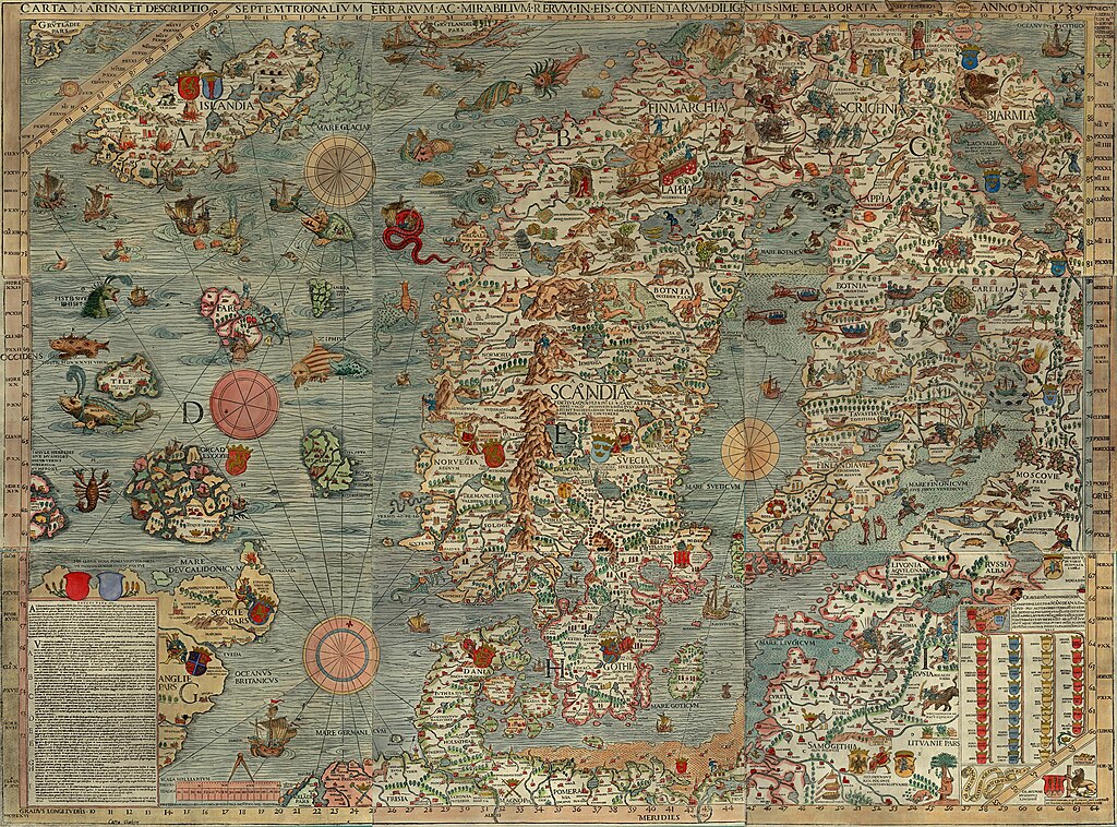
The Monsters of Olaus Magnus’ 1539 Map

Monsters and maps.  (Click here for an interactive version.)
Olaus Magnus, Carta Marina..., 1539.
In 1538, after twelve years of work, Swedish Catholic priest Olaus Magnus (1490–1557) had his large map of the Nordic northland published in Venice.  The numerous sea monsters, land creatures, and vignettes immediately capture a viewer's attention.  The Carta Marina, as it was called, is made up of nine large woodblock-printed sheets, measuring about 5.5 feet wide and 4 feet high (1.70 m by 1.25 m).  The editions that have come down to the present, housed in Munich and Uppsala, are delightfully covered.

The full name of the map is: Carta marina et Descriptio septemtrionalium terrarum ac mirabilium rerum in eis contentarum, diligentissime elaborata Anno Domini 1539 Veneciis liberalitate Reverendissimi Domini Ieronimi Quirini ("A Marine map and Description of the Northern Lands and of their Marvels, most carefully drawn up at Venice in the year 1539 through the generous assistance of the Most Honourable Lord and Patriarch Hieronymo Quirino").  It was the first map printed in the south of Europe to show extensive and accurate detail as well as place-names.  Olaus Magnus also penned a book titled Historia de Gentibus Septentrionalibus ("A Description of the Northern Peoples"), which was printed in 1555.

Scholar Joseph Nigg has just released a book about the Carta Marina with the University of Chicago Press called Sea Monsters: A Voyage Around the World’s Most Beguiling Map.  The online newsmagazine Slate has posted a short introduction to the map, complete with a fully zoomable and clickable depiction of some of its monstrous creatures.

Chet Van Duzer, a scholar at the Library of Congress, has also recently published a book about sea monsters on maps titled, Sea Monsters on Medieval and Renaissance Maps.  As Van Duzer notes: "The creatures look purely fantastic. They all look like they were just made up.  But, in fact, a lot of them come from what were considered, at the time, scientific sources."

10 November 2013

The Influence of Greco-Roman Mapping on the First European Age of Exploration

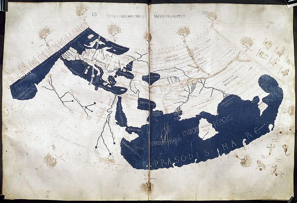
Ptolemy's world map, reconstituted from Ptolemy's Geographia in the 15th century
The Institute for the Study of the Ancient World at New York University is hosting an exhibit on the legacy of Greco-Roman mapmaking, and, since many of our surviving examples of such maps are recreations from the Renaissance, how the cartography of Greece and Rome was rediscovered and utilized in a whole new era.

The exhibit, titled "Measuring and Mapping Space: Geographic Knowledge in Greco-Roman Antiquity" is located in Manhattan and runs through January 5, 2014, but has a very strong web presence.  Included online are copies of the printed material, online resources, a YouTube video, and an extensive checklist of objects on display.

Roger S. Bagnall, a director at the institute, noted that "Our exhibitions and digital teams present a 21st-century approach to the ancient mentality concerning geographic space and how it is represented."  Scholars should, when possible, try to see the world in the eyes of the historical subjects they are researching.  One of the exhibit's guest curators said that "Geography is not just maps.  There is also the cognitive side underlying mapping."

As John Wilford Noble notes in a New York Times piece on the exhibit, the worldview and conceptions of the classical thinkers deeply influenced the explorers of the first European Age of Exploration.  Wilford notes: "Even Ptolemy’s errors were influential. Instead of sticking to Eratosthenes’ more accurate estimate of Earth’s size, Ptolemy handed down a serious underestimate that later apparently emboldened Columbus to think he could sail west to reach China or Japan."


30 October 2013

Penn Museum's Great Voyages: Travels, Triumphs, and Tragedies Lecture Series

Gilgamesh, the first explorer?
(Source: The Chaldean Account of Genesis, 1876)
The University of Pennsylvania Museum of Archaeology and Anthropology, commonly called Penn Museum, is hosting a monthly lecture series through June 2014 titled Great Voyages: Travels, Triumphs, and Tragedies.  The series will feature a range of topics by experts in several fields.  The upcoming lectures are:

November 6
Ignacio Gallup-Diaz, Associate Professor, History, Bryn Mawr College
Ferdinand Magellan and the First Circumnavigation of the Globe, 1519–1522

December 4
Paul Cobb, Professor, Islamic History, University of Pennsylvania
Traveler's Tips from the 14th Century: The Detours of Ibn Battuta

January 8
Steve Tinney, Associate Curator-in-Charge, Penn Museum Babylonian Section
Gilgamesh: Journeys to the End of the World

February 5
Robert Ballard, Director of the Center for Ocean Exploration at the Graduate school of Oceanography at URI, and President of Ocean Exploration Trust
Lost History Beneath the Sea from Titanic to the Iron Age

March 5
Clark Erickson, Curator-in-Charge, Penn Museum American Section
Thor Heyerdahl and Kon Tiki: A Grand Experiment in Archaeology

April 2
Peter Struck, Associate Professor, Classical Studies, University of Pennsylvania
The Odyssey, Nostalgia, and the Lost Home

May 7
Brian Rose, Curator-in-Charge, Penn Museum Mediterranean Section
Searching for the Golden Fleece with Jason and the Argonauts

June 4
Michael Weisberg, Associate Professor, Philosophy, University of Pennsylvania
Darwin's Beagle Voyage

Check out Penn Museum's website for further details.


14 October 2013

Osher Map Library Presents "To the Ends of the Earth and Back"

Mercator's view of the North Pole.
Gerardus Mercator, Septentrionalium Terrarum descriptio, 1623.
The Osher Map Library at the University of Southern Maine in Portland, Maine, is now hosting an exhibit titled: "To the Ends of the Earth... and Back: Selections from the Jay I. Kislak Polar Collection," highlighting the centuries old quest to understand, map, and explore the Earth's polar regions.

"To the Ends of the Earth" showcases more than eighty maps, charts, photographs, and other artifacts, from the Jay I. Kislak Polar Collection.  The exhibit is on view through February 27, 1:00 to 4:00 p.m., Tuesdays to Thursdays (with tours available by appointment).


29 September 2013

Atlas of True Names

Atlas of True Names: World Map (2008) from Kalimedia
(click to enlarge)
Explorers and cartographers, and those who study them, like members of the Society for the History of Discoveries, are often awash in place-names.  Toponyms tell us about the history of a place, who named it, why they named it, etc.  Explorers, like Columbus or La Salle or Cook gave names, recorded indigenous names, and mapmakers adopted and/or altered the geographical information they received.

But what do the names mean?  Stephan Hormes and Silke Puest at Kalimedia have created a wonderful series of maps they call an "Atlas of True Names."  They've replaced place-names like Reykjavik and and Washington with their true meanings, "Smoky Place" and "Marshton."  The Atlantic Ocean becomes "World Stream by the Mountain of Mountains."  Portugal is "Warm Port."

Check out their world map of True Names
And visit their website for more examples from their Atlas of True Names