05 September 2013

Society for the History of Encounters?

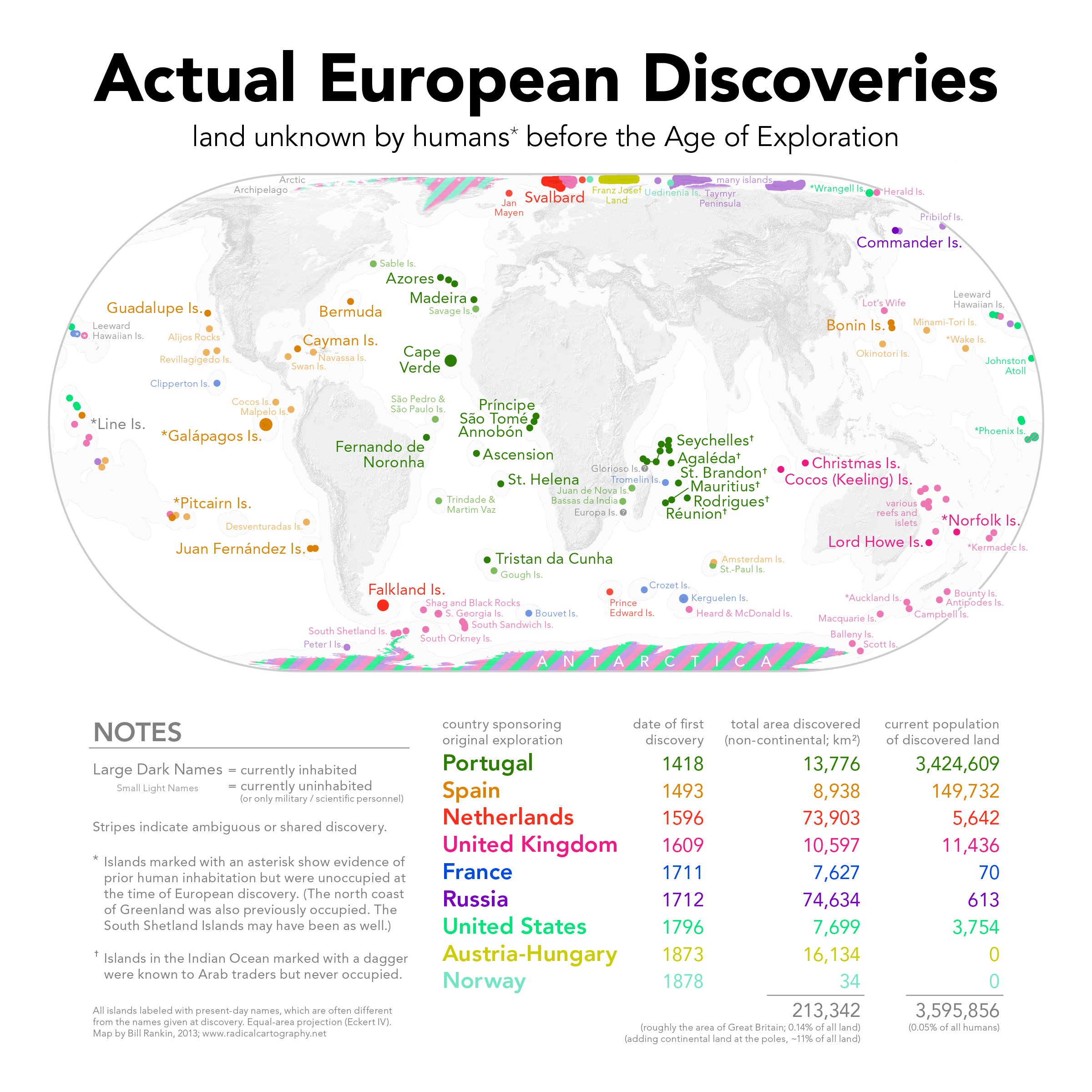
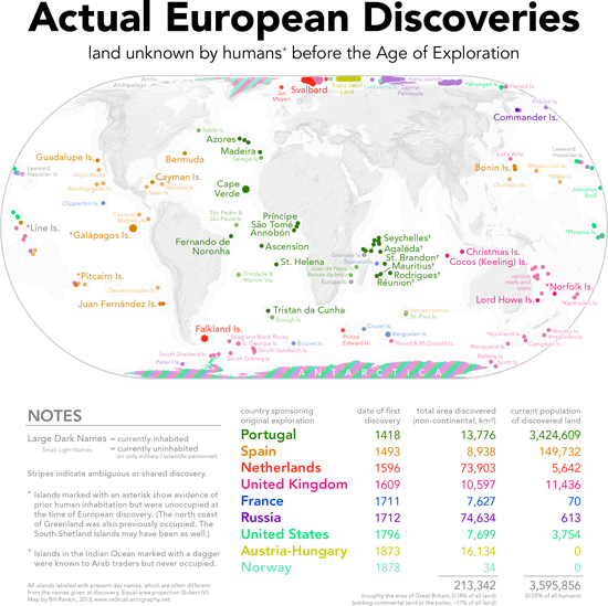
"Islands and ice, mostly," says Bill Rankin of his map Actual European Discoveries.
(Click the link below for a larger version to see detail.)
In the past few decades, there has been a discussion amongst historians, geographers, anthropologists and the like about just what to call what was going on in the “Age of Discovery.”  Was it “discovery”? “exploration”? “encounter”? “invasion”? “reconnaissance”?

The term for the longest time has been discovery.  Older histories (and the general public still) used “Columbus’s discoveries” or “Columbus discovered America” and the like.  But this has been pointed out to be Eurocentric.  Columbus ran across places that other people had already discovered!  They were discovered by the indigenes who lived there!  So scholars, like Brian Harley, used terms such as the “Columbian encounter.”  The word encounter, indeed, has become the popular term used in academe these days, though it has its detractors.  “Encounter” is here to stay alongside “discovery.”  As Marvin Lunenfeld writes in the introduction to 1492—Discovery, Invasion, Encounter: “The neutral word encounter has recently come into general scholarly use.  Encounter seems friendly enough, evoking the idea of social gatherings….  If all that happened in 1492 was that Columbus ‘encountered’ the Amerindians, the historian would successfully escape the ethnocentric connotations of a discovery and the violent implications of an invasion.”

Dr. Bill Rankin, Assistant Professor of History of Science at Yale University, has constructed a map titled Actual European Discoveries for his website Radical Cartography that shows just what little Europeans actually discovered in the sense of no other humans were there to greet them.  As Rankin notes (a tad sarcastically, he admits): “Every Columbus Day, we’re reminded of the difference between discovery and “discovery”—and rightly so.  But let's not sell Europe short; after all, European explorers found plenty of diminutive islands that no human had ever seen before, along with extravagant amounts of ice and snow.”

If the Society for the History of Discoveries was holding its fourth annual meeting this year instead of its fifty-fourth, would it be named the “Society for the History of Encounters”?


26 August 2013

Speakers at the Fifty-fourth Annual Meeting of the Society for the History of Discoveries

A depiction of what might be Florida from the 1502 Cantino map.
The following is a list if speakers for the Fifty-fourth Annual Meeting of the Society for the History of Discoveries (SHD), which will be held this year in Tampa, Florida, at the Tampa Bay History Center (TBHC) from October 31–November 3, 2013.

Speakers

ALTIC, Mirela (Croatia): "Missionary Cartography of the Amazon after the Treaty of Madrid (1750): A Jesuit's Contribution to the Demarcation of Imperial Frontiers"

BECK, Lauren: "A Moroccan Ambassador’s Travelogue in Spain (1690-91) and Its Legacy"

BLICK, Jeffrey: "The Case for San Salvador as the Site of the 1492 Columbus Landfall: Principles of Historical Archaeology Applied to Current Evidence"

COWDREY, Peter: "Mapping La Florida"

DELIZ, Michael: "The Digital Reconstruction of El Mapa Militar de Puerto Rico: An Analysis of the Spanish Military Topographic Project in Puerto Rico, 1872-1897"

EDNEY, Matthew: "The Transatlantic Circulation of Geographical Maps before 1763"

GASPAR, Joaquim (Portugal): "The representation of the Western Indies in the early Iberian cartography: a cartometric approach"

MATTHEWS, Jim: "Love Letters and Lesser Beings: Travel Accounts of French and Moroccan Diplomats during the Ancien Régime"

McGUIRK, Don: "Is North America REALLY pictured on the Waldseemüller World Map of 1507?"

MILANICH, Gerald T. (Florida Museum of Natural History): "Early Encounters by European Explorers with Native Americans in Florida"

PFLEDERER, Richard: "Exploring the Manuscript Cartography of Florida and its connection to Exploration and Settlement of the Territory"

SKURNIK, Johanna (Finland): "Circulating exploration knowledge: tracing the discussion of the interior of Australia in the 1840s"

TOUCHTON, J. Thomas & KITE-POWELL, Rodney (Tampa Bay History Center): "Charting the Land of Flowers: 500 Years of Florida Maps" – An introduction to the temporary exhibition at the Tampa Bay History Center

WALKER, Jim: "Alterity and Allegory: Cannibalism, Early Maps and European Conceptions of Amerindian Civility"

Essay Contest Winner

MARCOTTE, Josh: "Culture, Contact and the Agency of Appropriation in a 1741 Map of Nagasaki"

Key Note Speaker

FRANCIS, J. Michael (University of South Florida, St. Petersburg): "Colonial Martyrs: Franciscans, Indians, and the Spiritual Conquest of Florida"

16 August 2013

Society for the History of Discoveries 54th Annual Meeting

Juan Ponce de León, who discovered and named Florida for the Spanish in 1513.
The Fifty-fourth Annual Meeting of the Society for the History of Discoveries (SHD) will be held this year in Tampa, Florida, at the Tampa Bay History Center (TBHC) from October 31–November 3, 2013.

Among the exhibits at this year's TBHC is "Charting the Land of Flowers: 500 Years of Florida Maps," celebrating the 500th anniversary of Florida's naming and discovery by Juan Ponce de León.

20 July 2013

Some Presentations from the "Re-Drawing Ptolemy" Conference

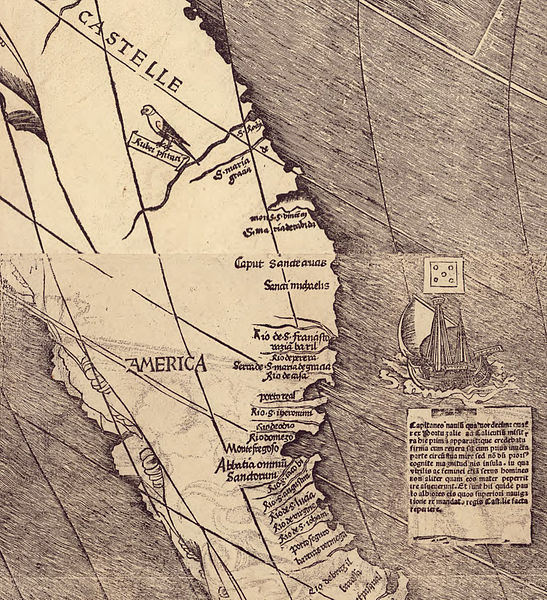
Detail of South America from the Waldseemüller map, Universalis Cosmographia, 1507.
On May 17-18, 2013, the Library of Congress hosted the conference "Re-Drawing Ptolemy: The Cartography of Martin Waldseemüller and Mathias Ringmann,"  sponsored by the Philip Lee Phillips Society, the Library of Congress’s Geography and Map Division, and the John Carter Brown Library.

Television channel C-SPAN3 filmed some the speaker's presentations and posted them online as "Waldseemuller's Map of America."


06 July 2013

Europeans on the east coast of Australia before Cook?

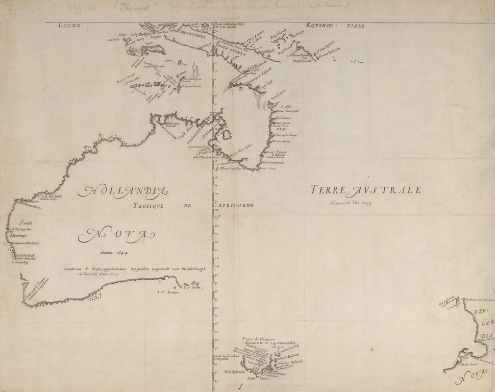
Hollandia Nova detecta 1644, a French copy (by Melchisedech Thevenot, 1663) of an earlier map by Dutch cartographer Joan Blaeu, based on information from voyages by Abel Tasman and Willem Jansz.  The map shows only the northern, western, and southern coasts of Australia.
The eastern coast of Australia, the history books tell us, was first seen by Europeans in 1770, when Captain James Cook's expedition explored the coast, but a skull discovered in 2011 might challenge that view.

Scientists from Australian National University tested a skull found in northern New South Wales in late 2011, revealing it to be from a Caucasoid male born around 1650—much too early to be a part of Cook's expedition.  Australia was first sighted by European explorers in early 1606 by the Dutch navigator Willem Janszoon.  Over the rest of the century, there are records of several Dutch expeditions exploring the northern, western, and southern coasts—but not the east.  (Some writers claim that the Portuguese may have discovered Australia earlier, but they offer no definitive proof.)

Could the Dutch, or some other European power, have explored the eastern coast of Australia before Cook's 1770 voyage?  Or can the skull be explained away?


18 June 2013

Defining Lines: Cartography in the Age of Empire — Duke University

Map of the West Coast of Africa from Sierra Leone
to Cape Palmas, including the colony of Liberia
, 1830.
The Nasher Museum of Art at Duke University will host an exhibit entitled "Lines of Control" between September 19, 2013, and February 2, 2014.  The exhibit focuses on the meaning of borders and part of the exhibit is called "Defining Lines: Cartography in the Age of Empire," and features presentations on the cartography of borders from Duke University undergraduate students in the BorderWork(s) Lab.  As part of this exhibit, BorderWork(s) students have posted videos explaining exploration, imperialism, cartography, and borders, such as this video on Africa by Lauren Jackson.

09 June 2013

La Salle's Great Lakes Ship Found?

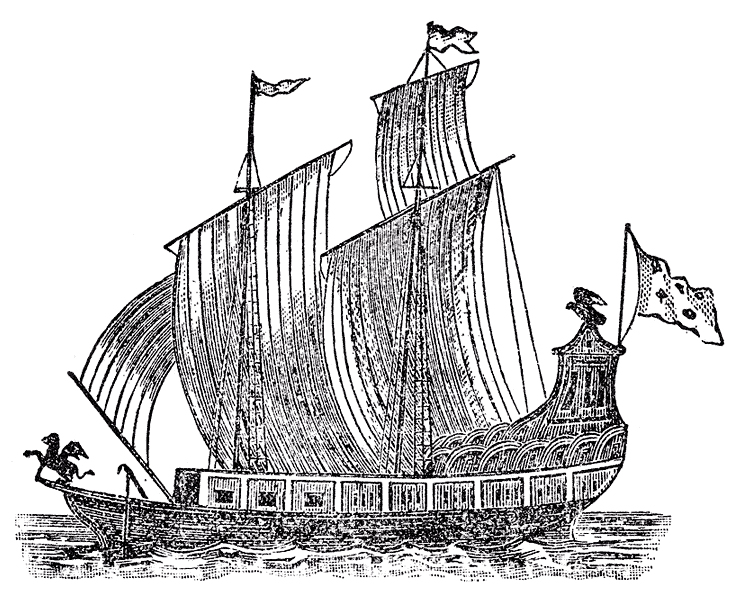
Woodcut of La Salle's Le Griffon, lost on the Great Lakes in 1679.
(From Father Louis Hennipin, Nouvelle Decouverte, Utrecht, 1697.)

The Great Lakes Exploration Group is soon set to take French archaeologists to the floor of Lake Michigan to determine if the wreckage they have found are indeed the remains of Le Griffon, that disappeared, presumed sunk, in 1679.  Le Griffon was built by order of the famed French explorer René-Robert Cavelier, Sieur de La Salle.