20 November 2013

The Monsters of Olaus Magnus’ 1539 Map

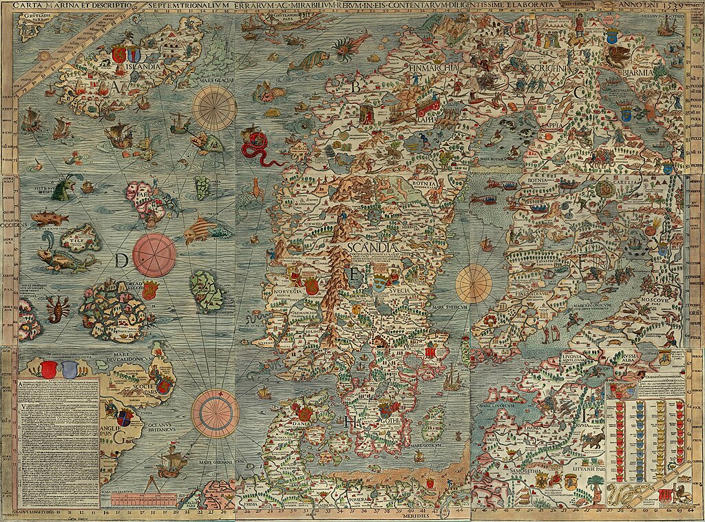
Monsters and maps.  (Click here for an interactive version.)
Olaus Magnus, Carta Marina..., 1539.
In 1538, after twelve years of work, Swedish Catholic priest Olaus Magnus (1490–1557) had his large map of the Nordic northland published in Venice.  The numerous sea monsters, land creatures, and vignettes immediately capture a viewer's attention.  The Carta Marina, as it was called, is made up of nine large woodblock-printed sheets, measuring about 5.5 feet wide and 4 feet high (1.70 m by 1.25 m).  The editions that have come down to the present, housed in Munich and Uppsala, are delightfully covered.

The full name of the map is: Carta marina et Descriptio septemtrionalium terrarum ac mirabilium rerum in eis contentarum, diligentissime elaborata Anno Domini 1539 Veneciis liberalitate Reverendissimi Domini Ieronimi Quirini ("A Marine map and Description of the Northern Lands and of their Marvels, most carefully drawn up at Venice in the year 1539 through the generous assistance of the Most Honourable Lord and Patriarch Hieronymo Quirino").  It was the first map printed in the south of Europe to show extensive and accurate detail as well as place-names.  Olaus Magnus also penned a book titled Historia de Gentibus Septentrionalibus ("A Description of the Northern Peoples"), which was printed in 1555.

Scholar Joseph Nigg has just released a book about the Carta Marina with the University of Chicago Press called Sea Monsters: A Voyage Around the World’s Most Beguiling Map.  The online newsmagazine Slate has posted a short introduction to the map, complete with a fully zoomable and clickable depiction of some of its monstrous creatures.

Chet Van Duzer, a scholar at the Library of Congress, has also recently published a book about sea monsters on maps titled, Sea Monsters on Medieval and Renaissance Maps.  As Van Duzer notes: "The creatures look purely fantastic. They all look like they were just made up.  But, in fact, a lot of them come from what were considered, at the time, scientific sources."

10 November 2013

The Influence of Greco-Roman Mapping on the First European Age of Exploration

Ptolemy's world map, reconstituted from Ptolemy's Geographia in the 15th century
The Institute for the Study of the Ancient World at New York University is hosting an exhibit on the legacy of Greco-Roman mapmaking, and, since many of our surviving examples of such maps are recreations from the Renaissance, how the cartography of Greece and Rome was rediscovered and utilized in a whole new era.

The exhibit, titled "Measuring and Mapping Space: Geographic Knowledge in Greco-Roman Antiquity" is located in Manhattan and runs through January 5, 2014, but has a very strong web presence.  Included online are copies of the printed material, online resources, a YouTube video, and an extensive checklist of objects on display.

Roger S. Bagnall, a director at the institute, noted that "Our exhibitions and digital teams present a 21st-century approach to the ancient mentality concerning geographic space and how it is represented."  Scholars should, when possible, try to see the world in the eyes of the historical subjects they are researching.  One of the exhibit's guest curators said that "Geography is not just maps.  There is also the cognitive side underlying mapping."

As John Wilford Noble notes in a New York Times piece on the exhibit, the worldview and conceptions of the classical thinkers deeply influenced the explorers of the first European Age of Exploration.  Wilford notes: "Even Ptolemy’s errors were influential. Instead of sticking to Eratosthenes’ more accurate estimate of Earth’s size, Ptolemy handed down a serious underestimate that later apparently emboldened Columbus to think he could sail west to reach China or Japan."